Property Lines: How to Find Lines Online
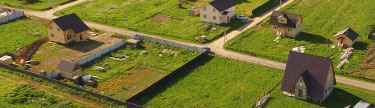
When having a house, people might be tempted to build an additional structure near the main building. Or if someone is not exactly satisfied with the size of the house, they might be willing to expand the house a bit. But there is one thing to be aware of - property (boundary) lines.
If accidentally or not knowing the limits of your property, you will build a structure on someone else’s land, you will be obliged to remove the structure. Before building something, you should learn exactly where your property lines end. To do that, you need to access the satellite maps with property lines online.
Ways To Find Boundary Lines
Apart from using satellite property line maps, which is the topic of this article, you could use some other ways to find where your property ends. Here are some of these methods:
- Find the property deed that you own.
- Check the property survey you had received when you bought the land or house.
- Visit the county assessor’s office and get the needed help.
- Hire the property surveyor to gain the property survey document if you don’t have it.
- Check the “satellite view of my house with property lines” option online on the county assessor’s website.
If you have just bought the land or house, you probably have the land survey document with exact property lines. Just check this document before building anything so you won’t get in trouble. If you can’t find this document or you have lost it, you could visit a building inspector responsible for the area where you live. Most likely, they have a copy of your survey.
You could also check the property deed. It’s a document you receive when you buy a land or house. It shows who is the owner of the land, and you can find the measurements of your land and the description of these measurements in words. It should also describe the landmarks.
If you see the landmarks, you can use them as a starting point to physically measure the lines of your land. That way, you will see where the boundaries of your property end, so you won’t accidentally build on another’s land.
If you are not sure how to do it, you could hire a professional surveyor. If you have a land deed, it won’t be difficult for him to physically measure the boundaries of your property. You have to be at home when the surveyor visits your house, so make sure you have free time. The surveyor will use the deed to mark all the landmarks and to mark the property lines with physical signs. That way you won’t build on your neighbor’s land.
But the easiest way is to check the satellite view of property boundaries. You could visit the office of the local county assessor, but most likely, you can access their website to see the map online. If this option is not available for you, you could visit the office and ask for the access to public maps. Name your street and the number of your house so you will receive the copy of the map showing the exact measurements of your property.
Property Lines Online
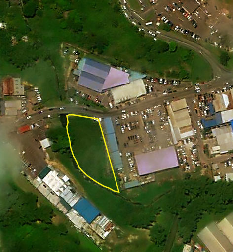
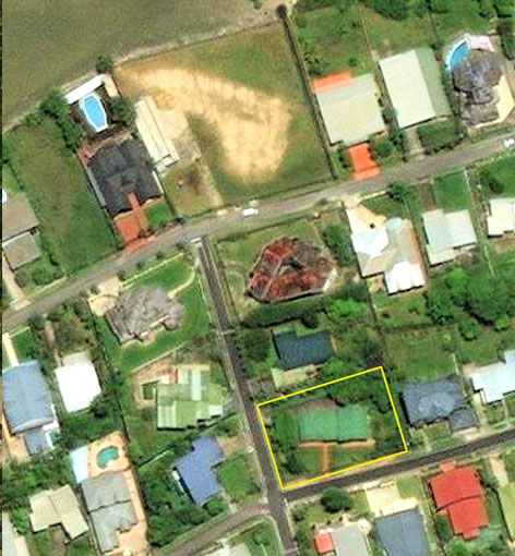
You can find different apps and websites that show the boundary lines online. Even Google Maps and Google Earth show the lines if you click on the correct mode. But it might not be the most accurate way. Moreover, there is no guarantee that your house is marked on those maps. The best way is to visit the official website of the county assessor.
Most county assessor’s websites have special online maps with tools where you can find the aerial view of property lines by address. Just type the address and the number of your house, and you will see the boundaries. It will depict the lines of your land and of all your neighbors. That way, you will see where you can build and which lines you shouldn’t cross. If you need physical lines, you could use landmarks to mark them. Or hire the professional.


Finding Boundaries Online: Instruction

You should complete several steps to access the satellite view of property lines. Several quick actions, and you will have the map of your land.
Step #1
Use Google or your preferred search engine to find the map. You could either type “county assessor’s website”, or “GIS” which is Geo information system. Open the map and use the search engine of the map. You might type your address or county’s name.
Step #2
You will find the lines of your land and the boundaries of all other structures. It will include the streets, some public buildings, the homes of your neighbors, etc. It should also have landmarks which you could find near your home. That way, it will be easier for you to distinguish the exact boundaries of your land and of other owners’ properties.
Step #3
You should save the map and print it out. That way, you won’t have to access the satellite view with property lines again if you will ever need to learn where the boundaries of your property begin and end.
Step #4
It would be wise to mark the lines physically by using a simple tape. Make sure you use the map that you have printed out. Mark the lines exactly how they are depicted on the map. If you are not sure that you could do it right, hire a surveyor who will do the job for you.
Conclusion
Most countries and districts have access to such online maps. It is rare that people can’t find the owners of land and are not able to find the measurements of their land online. The information is usually up to date, so it won’t be a problem for you to access the map online and find the borderlines of your property.